

Massive Snow Storm Heading Our Way
/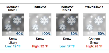 A potentially dangerous storm that could dump between 8 and 16 inches on Schroon is expected to arrive here on Monday night and go through to Wednesday. The National Weather Service has issued a Winter Storm Watch for northern New York. From The National Weather Service:
The storm is a result of two storms which will bring blizzard conditions to parts of the Northern Plains and a wintry mix of precipitation into the Mid-Atlantic Sunday night through Monday. As one storm reaches the Atlantic, heavy snow is possible over upstate New York and parts of New England Monday night into Tuesday.
More from The National Weather Service after the jump:
* LOCATIONS...VERMONT AND NORTHERN NEW YORK.

* HAZARD TYPES...SNOW AND GUSTY WINDS.

* ACCUMULATIONS...9 TO 16 INCHES OF SNOW.

* MAXIMUM SNOWFALL RATE...UP TO 1 INCH PER HOUR...MAINLY TUESDAY
  AFTERNOON THROUGH TUESDAY EVENING.

* TIMING...SNOW IS EXPECTED TO BEGIN AROUND OR AFTER MIDNIGHT
  MONDAY NIGHT AND CONTINUE INTO EARLY WEDNESDAY MORNING.

* IMPACTS...TRAVEL WILL BECOME DIFFICULT ON ANY UNTREATED ROADS
  EARLY TUESDAY MORNING AND CONTINUING INTO TUESDAY NIGHT AND
  EARLY WEDNESDAY MORNING. GUSTY SOUTH AND SOUTHEASTERLY WINDS
  COMBINED WITH HEAVY SNOW COULD BRING DOWN TREE LIMBS AND PRODUCE
  SCATTERED POWER OUTAGES.

* WINDS...SOUTH 15 TO 25 MPH WITH GUSTS UP TO 35 MPH.

* TEMPERATURES...LOWS IN THE LOWER 20S. HIGHS IN THE LOWER 30S.

* VISIBILITIES...ONE HALF MILE OR LESS IN SNOW LATE MONDAY NIGHT
  AND TUESDAY.