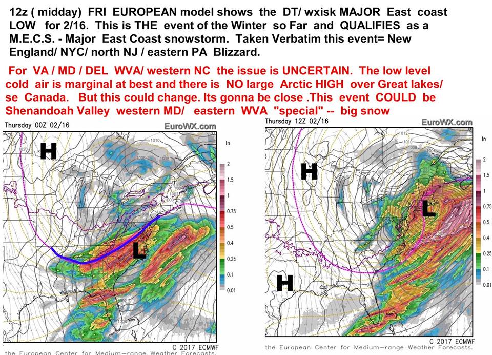

Big, VERY BIG, Weather Events In The Days Ahead?
/
There could be some big time snow headed our way. Then again, as it's the 'Dacks, maybe not. But this future storm has captured the attention of local weather guru Tony Tenda.
Although not a professional, Tony has a very good track record in alerting locals to weather events, and here is his guidance:
"Winter Storm Watches have been upgraded to Warnings now. Looks like 12", to as much as 18" is possible according to latest guidance. Those amounts carry on south of Albany as well. On a historical note this is the first Winter Storm Warning for Northern NY-Northern New England in about 3 winters, except for a couple isolated areas. Very unusual".
The National Weather Service has issued the following weather warning for our area.
WINTER STORM WARNING IN EFFECT FROM 10 AM SUNDAY TO 7 PM EST
MONDAY...

The National Weather Service in Burlington has issued a Winter
Storm Warning for heavy snow...which is in effect from 10 AM
Sunday to 7 PM EST Monday. The Winter Storm Watch is no longer in
effect.

* Locations...Northern New York and Vermont.

* Hazard Types...Snow...heavy at times.

* Accumulations...8 to 14 inches of snow with higher amounts
possible in the higher terrain.

* Maximum Snowfall Rate...up to 1 inch per hour...mainly late
Sunday through Sunday night.

* Timing...Snow will spread into the region late Sunday morning
and afternoon. Snow will be heaviest later Sunday afternoon
through Sunday night.

* Impacts...Snow covered roads and low visibilities will create
hazardous travel conditions.

* Winds...Southeast 5 to 15 mph on Sunday...shifting northeast 10
to 20 mph with gusts up to 35 mph on Monday.

* Temperatures...Highs Sunday and Monday in the upper 20s. Lows
Sunday night range from 12 to 22.

* Visibilities...Less than one quarter mile at times.