

The Big Dump of 2013 Heading Our Way?
/ A major winter storm is heading our way – and could dump anywhere from 7 – 15 inches in our area.
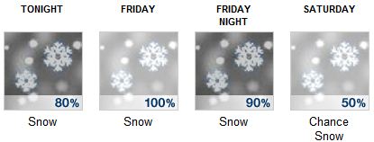
Further south and to the east that prediction could go even higher and get a lot more complicated and dangerous with wind gusts potentially in the range of 60 – 75 miles per hour. (That’s as of 3PM Thursday)
The headlines for our area from the National Weather Service:
LOCATIONS...ALL OF NORTHERN NEW YORK...AS WELL AS CENTRAL AND NORTHERN VERMONT.
HAZARD TYPES...MODERATE TO HEAVY SNOW.
ACCUMULATIONS...7 TO 15 INCHES OF SNOW.
TIMING...SNOW WILL DEVELOP OVER NORTHERN NEW YORK AROUND MIDNIGHT TONIGHT AND SPREAD EAST INTO VERMONT BY EARLY FRIDAY MORNING.
IMPACTS...AREA ROADWAYS WILL BECOME HAZARDOUS AFTER MIDNIGHT TONIGHT...AND ESPECIALLY DURING THE FRIDAY MORNING AND FRIDAY EVENING COMMUTES.